|
Era of Disunity 1.
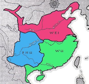
After the collapse of the Later Han Dynasty in 220, China split into three kingdoms. These were the Wei in the north, the Wu in the east and south, and the Shu in the Sichuan Basin. It was militarily unstable configuration and Inner China was reunited in AD 265 by the Western Jin Dynasty, the successors of the Wei. In economic terms, however this tripartite division reflected a reality that long endured. It is still possible to think of the Northern Song empire, 700 years after the Three Kingdoms, as having been composed of three great regional markets corresponding to the vanished realms of Wei, Wu and Shu. The status of the northwest was slightly ambivalent, as it had links with both the northern region and Sichuan. These geographical divisions are underscored by the fact that the communications routes between the three economic regions were all man-made: the Grand Canal linking north and south, the hauling-way through the gorges of the Yangzi linking the south and Sichuan and the Gallery Road joining Sichuan and the northwest. Return to 7. Era of Disunity Choices |
|
Three Kingdoms Map
|