|
5. Qin Dynasty Map - (221 to 206 BC - 16 Years)
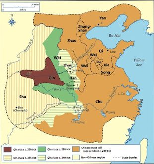
Much of what is China proper was unified in 221BC. In that year, the most aggressive of the Warring States, subjugated the last of its rival states. Qin (formally known as Ch'in, from the English word China probably derived). In subjugating the six other major states of Eastern Zhou, the Qin kings had relied heavily on standardizing legal codes and bureaucratic procedures. To silence criticism of imperial rule, the kings banished or put to death many dissenting Confucian scholars and confiscated and burned their books. Qin aggrandizement was aided by frequent military expeditions pushing out the frontiers in the north and south. To fend off barbarian intrusion, the fortification walls built by various Warring States were connected to make a 5,000-kilometer Great Wall. The Great Wall is actually four great walls rebuilt or extended during the Western Han, Sui, Jin and Ming periods. A number of public works projects were also undertaken to consolidate and strengthen imperial rule. These activities required enormous levies of manpower and resources, not to mention repressive measures. Revolts broke out as soon as the first Qin emperor died in 210 BC. The dynasty was extinguished less than twenty years after its triumph but the imperial system initiated set the pattern for the next two millennia. ⇦ Back to 4. Eastern Zhou Return to Dynasty Maps Page 1 On to 6. Han ⇨ |
|
Qin Dynasty Map
|