|
Dennis Fink (Air Force)
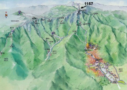
20. Yongmun San in 1970 Yongmunsan Mountain: 1,157m high. It is located 8km Northeast of Yangpyeong and 42 km east of Seoul. It is a branch of Gwanju Mountain Range, but independently has an elevated peak spreading 8 km from the east to the west and 5km from the south to the north. The main peak is Yongmunsan and the mountains form large group with Doilbong Peak (864m) 5.5km to the northeast, Jungwonsan Mountain (800m) 4.5 km to the east and Baekunbong Peak (940m) 3.5 km to the southeast. The top of the mountain is flat and the ridge lines are well developed, especially between Yongmun and Jungwon where there are grand valleys known as, Yongye and Jogye. The plateaus in the middle of this site are above the 100m high rock cliff so it looks similar to Geumgangsan Mountain. The slope on the north side is low and on the south side is high. ⇦ Back to Page 19 On to Page 1 ⇨Hi-Res Pic (162K) Back to USAF Choices Page 3 |