|
Algeria
Background:
After a century of rule by France, Algeria became independent in
1962. The surprising first round success of the fundamentalist FIS (Islamic
Salvation Front) party in the December 1991 balloting caused the army to
intervene, crack down on the FIS, and postpone the subsequent elections. The
fundamentalist response has resulted in a continuous low-grade civil conflict
with the secular state apparatus, which nonetheless has allowed elections
featuring pro-government and moderate religious-based parties. The FIS's armed
wing, the Islamic Salvation Army, disbanded in January 2000 and many armed
militants of other groups surrendered under an amnesty program designed to
promote national reconciliation.
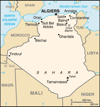
Location:
Northern Africa, bordering the Mediterranean Sea, between Morocco and
Tunisia
Area: total: 2,381,740 sq km water: 0 sq km land: 2,381,740 sq km.
Area - comparative: slightly less than 3.5 times the size of Texas.
Land boundaries: total: 6,343 km border countries: Libya 982 km, Mali 1,376
km, Mauritania 463 km, Morocco 1,559 km, Niger 956 km, Tunisia 965 km, Western
Sahara 42 km.
Coastline: 998 km.
Climate and Terrain:
Climate: arid to semiarid; mild, wet winters with hot, dry summers along coast;
drier with cold winters and hot summers on high plateau; sirocco is a hot,
dust/sand-laden wind especially common in summer.
Terrain: mostly high plateau and desert; some mountains; narrow, discontinuous
coastal plain.
Natural resources: petroleum, natural gas, iron ore, phosphates, uranium, lead,
and zinc.
People:
Population: 32,818,500.
Ethnic groups: Arab-Berber 99%, European less than 1%.
Religions: Sunni Muslim (state religion) 99%, Christian and Jewish 1%.
Languages: Arabic (official), French, Berber dialects.
Government:
Government type: Republic
Capital: Algiers
Economy overview:
The hydrocarbons sector is the backbone of the economy,
accounting for roughly 60% of budget revenues, 30% of GDP, and over 95% of
export earnings. Algeria has the fifth-largest reserves of natural gas in the
world and is the second-largest gas exporter; it ranks 14th in oil reserves.
Algeria's financial and economic indicators improved during the mid-1990s, in
part because of policy reforms supported by the IMF and debt rescheduling from
the Paris Club. Algeria's finances in 2000-03 benefited from substantial trade
surpluses, record foreign exchange reserves, and reductions in foreign debt.
Real GDP has risen due to higher oil output and increased government spending.
The government's continued efforts to diversify the economy by attracting
foreign and domestic investment outside the energy sector, however, has had
little success in reducing high unemployment and improving living standards.
Statistics:
Telephones - main lines in use: 2.3 million.
Telephones - mobile cellular: 33,500.
Radio broadcast stations: AM 25, FM 1, shortwave 8.
Radios: 7.1 million.
Television broadcast stations: 46 (plus 216 repeaters).
Televisions: 3.1 million.
Internet users: 180,000.
Railways: total: 3,973 km.
Highways: total: 104,000 km paved: 71,656 km, unpaved: 32,344 km.
Airports: 136.
Airports - with paved runways: total: 54, with unpaved runways: total: 82.
Heliports: 1.
Return to Visiting Locations
|