|
Bangladesh
Background:
Bangladesh came into existence in 1971 when Bengali East Pakistan seceded from
its union with West Pakistan. About a third of this extremely poor country
floods annually during the monsoon rainy season, hampering economic development.
Location:
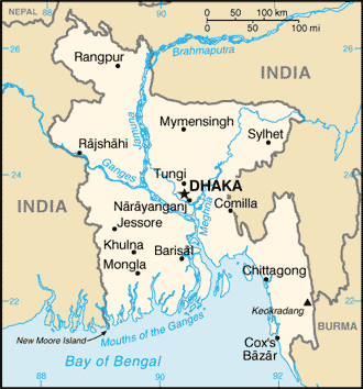
Location: Southern Asia, bordering the Bay of Bengal, between Burma and India.
Area: Total: 144,000 sq km, land: 133,910 sq km, water: 10,090 sq km.
Area - comparative: Slightly smaller than Iowa/
Land boundaries: Total: 4,246 km, border countries: Burma 193 km, India 4,053
km.
Coastline: 580 km.
Climate and Terrain:
Climate: Tropical; mild winter (October to March); hot, humid summer (March to
June); humid, warm rainy monsoon (June to October.)
Terrain: Mostly flat alluvial plain; hilly in southeast.
Natural resources: Natural gas, arable land, timber, coal.
People:
Population: 138,448,210.
Ethnic groups: Bengali 98%, tribal groups, non-Bengali Muslims.
Religions: Muslim 83%, Hindu 16%, other 1%.
Languages: Bangla (official, also known as Bengali), English.
Government:
Government type: Parliamentary democracy.
Capital: Dhaka.
Economy overview:
Despite sustained domestic and international efforts to improve economic and
demographic prospects, Bangladesh remains a poor, overpopulated, and
ill-governed nation. Although half of GDP is generated through the service
sector, nearly two-thirds of Bangladeshis are employed in the agriculture
sector, with rice as the single-most-important product. Major impediments to
growth include frequent cyclones and floods, inefficient state-owned
enterprises, inadequate port facilities, a rapidly growing labor force that
cannot be absorbed by agriculture, delays in exploiting energy resources
(natural gas), insufficient power supplies, and slow implementation of economic
reforms. Economic reform is stalled in many instances by political infighting
and corruption at all levels of government.
Statistics:
Telephones - main lines in use: 500,000.
Telephones - mobile cellular: 283,000.
Radio broadcast stations: AM 12, FM 12, shortwave 2.
Radios: 6.15 million.
Television broadcast stations: 15.
Televisions: 770,000.
Internet users: 150,000.
Railways: total: 2,706 km.
Highways: Total: 207,486 km, paved: 19,773 km, unpaved: 187,713 km.
Airports - with paved runways: 15,
with unpaved runways: 3.
Return to Visiting Locations
|