|
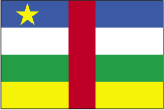
Central African Republic
Background:
The former French colony of Ubangi-Shari became the Central African Republic
upon independence in 1960. After three tumultuous decades of misrule - mostly
by military governments - civilian rule was established in 1993 and lasted for
one decade. In March 2003 a military coup deposed the civilian government of
President Ange-Felix PATASSE and has since established a new government.
Location:
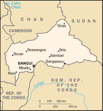
Location: Central Africa, north of Democratic Republic of the Congo
Area: Total: 622,984 sq km.
Area - comparative: Slightly smaller than Texas.
Land boundaries: Total: 5,203 km, border countries: Cameroon 797 km, Chad
1,197 km, Democratic Republic of the Congo 1,577 km, Republic of the Congo 467
km, Sudan 1,165 km.
Climate and Terrain:
Climate: Tropical; hot, dry winters; mild to hot, wet summers.
Terrain: Vast, flat to rolling, monotonous plateau; scattered hills in
northeast and southwest
Natural resources: Diamonds, uranium, timber, gold, oil, hydropower.
People:
Population: 3,683,538.
Ethnic groups: Baya 33%, Banda 27%, Mandjia 13%, Sara 10%, Mboum 7%, M'Baka 4%,
Yakoma 4%, other 2%.
Religions: Indigenous beliefs 35%, Protestant 25%, Roman Catholic 25%, Muslim
15%. Note: animistic beliefs and practices strongly influence the Christian
majority.
Languages: French (official), Sangho (lingua franca and national language),
tribal languages.
Government type: Republic
Capital: Bangui.
Independence: 13 August 1960 (from France).
Government:
Government type: Republic
Capital: Bangui.
Independence: 13 August 1960 (from France).
Economy overview:
Subsistence agriculture, together with forestry, remains the backbone of the
economy of the Central African Republic (CAR), with more than 70% of the
population living in outlying areas. The agricultural sector generates half of
GDP. Timber has accounted for about 16% of export earnings and the diamond
industry for 54%. Important constraints to economic development include the
CAR's landlocked position, a poor transportation system, a largely unskilled
work force, and a legacy of misdirected macroeconomic policies. Factional
fighting between the government and its opponents remains a drag on economic
revitalization, with GDP growth likely to be no more than 1.3% in 2003.
Distribution of income is extraordinarily unequal. Grants from France and the
international community can only partially meet humanitarian needs.
Statistics:
Telephones - main lines in use: 9,500.
Telephones - mobile cellular: 710.
Radio broadcast stations: AM 1, FM 5, shortwave 1.
Radios: 283,000.
Television broadcast stations: 1.
Televisions: 18,000.
Internet users: 2,000.
Railways: 0 km.
Highways: Total: 23,810 km, paved: 643 km. unpaved: 23,167 km.
Airports - with paved runways: Total: 3,
with unpaved runways: Total: 47.
Return to Visiting Locations
|