|
Djibouti
Background:
The French Territory of the Afars and the Issas became Djibouti in 1977. Hassan
Gouled Apitidon installed an authoritarian one-party state and proceeded to
serve three consecutive six-year terms as president. Unrest among the Afars
minority during the 1990's led to multi-party elections resulting in President
Ismail Omar Guelleh attaining office in May 1999. A peace accord in 2001 ended
the final phases of a ten-year uprising by Afar rebels. Djibouti occupies a
very strategic geographic location at the mouth of the Red Sea and serves as an
important transshipment location for goods entering and leaving the east
African highlands. Guelleh favors close ties to France, which maintains a
significant military presence in the country.
Location:
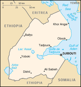
Location: Eastern Africa, bordering the Gulf of Aden and the Red Sea, between
Eritrea and Somalia.
Area: Total: 23,000 sq km, water: 20 sq km. land: 22,980 sq km.
Area - comparative: Slightly smaller than Massachusetts
Land boundaries: Total: 516 km border countries: Eritrea 109 km, Ethiopia 349
km, Somalia 58 km.
Coastline: 314 km.
Climate and Terrain:
Climate: Desert; torrid, dry.
Terrain: Coastal plain and plateau separated by central mountains .
People:
Population: 457,130.
Ethnic groups: Somali 60%, Afar 35%, French, Arab, Ethiopian, and Italian 5%.
Religions: Muslim 94%, Christian 6%.
Languages: French (official), Arabic (official), Somali, Afar.
Government:
Government type: Republic.
Capital: Djibouti.
Independence: 27 June 1977 (from France)
Economy overview:
The economy is based on service activities connected with the country's
strategic location and status as a free trade zone in northeast Africa.
Two-thirds of the inhabitants live in the capital city, the remainder being
mostly nomadic herders. Scanty rainfall limits crop production to fruits and
vegetables, and most food must be imported. Djibouti provides services as both
a transit port for the region and an international transshipment and refueling
center. It has few natural resources and little industry. The nation is,
therefore, heavily dependent on foreign assistance to help support its balance
of payments and to finance development projects. An unemployment rate of 50%
continues to be a major problem. Inflation is not a concern, however, because
of the fixed tie of the franc to the US dollar.
Statistics:
Telephones - main lines in use: 10,000.
Telephones - mobile cellular: 5,000.
Radio broadcast stations: AM 1, FM 2.
Radios: 52,000.
Television broadcast stations: 1.
Televisions: 28,000.
Internet users: 3,300.
Railways: Total: 100 km.
Highways: Total: 2,890 km, paved: 364 km. unpaved: 2,526 km.
Airports - with paved runways: 3, with unpaved runways: 10.
Return to Visiting Locations
|