|
East Timor (also known as Timor-Leste)
Background:
The Portuguese colony of Timor declared itself independent from Portugal on 28
November 1975 and was invaded and occupied by Indonesian forces nine days
later. It was incorporated into Indonesia in July 1976 as the province of East
Timor. A campaign of pacification followed over the next two decades, during
which an estimated 100,000 to 250,000 individuals lost their lives. On 30
August 1999, in a UN-supervised popular referendum, the people of East Timor
voted for independence from Indonesia. During 1999-2001, pro-integrationist
militias - supported by Indonesia - conducted indiscriminate violence. On 20
May 2002, East Timor was internationally recognized as an independent state and
the world's newest democracy.
Location:
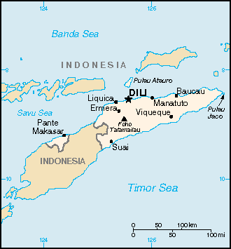
Location: Southeastern Asia, northwest of Australia in the Lesser Sunda Islands
at the eastern end of the Indonesian archipelago; note - East Timor includes
the eastern half of the island of Timor, the Oecussi (Ambeno) region on the
northwest portion of the island of Timor, and the islands of Pulau Atauro and
Pulau Jaco
Area: Total: 15,007 sq km.
Area - comparative: Slightly larger than Connecticut.
Land boundaries: Total: 228 km; border countries: Indonesia 228 km.
Coastline: 706 km.
Climate and Terrain:
Climate: Tropical; hot, humid; distinct rainy and dry seasons.
Terrain: Mountainous.
Natural resources: Gold, petroleum, natural gas, manganese, marble.
People:
Population: 997,853; note: other estimates range as low as 800,000.
Ethnic groups: Austronesian (Malayo-Polynesian), Papuan, small Chinese
minority.
Religions: Roman Catholic 90%, Muslim 4%, Protestant 3%, Hindu 0.5%, Buddhist,
Animist.
Languages: Tetum (official), Portuguese (official), Indonesian, English note:
there are about 16 indigenous languages; Tetum, Galole, Mambae, and Kemak are
spoken by significant numbers of people.
Government:
Government type: Republic.
Capital: Dili.
Economy overview:
In late 1999, about 70% of the economic infrastructure of East Timor was laid
waste by Indonesian troops and anti-independence militias, and 260,000 people
fled westward. Over the next three years, however, a massive international
program, manned by 5,000 peacekeepers (8,000 at peak) and 1,300 police
officers, led to substantial reconstruction in both urban and rural areas. By
mid-2002, all but about 50,000 of the refugees had returned. The country faces
great challenges in continuing the rebuilding of infrastructure and the
strengthening of the infant civil administration. One promising long-term
project is the planned development of oil resources in nearby waters.
Statistics:
Railways: 0 km.
Highways: Total: 3,800 km, paved: 428 km, unpaved: 3,372 km.
Airports - with paved runways: 3,
with unpaved runways: 5.
Heliports: 1.
Return to Visiting Locations
Return Opening Page
|