|
Mauritania
Background:
Independent from France in 1960, Mauritania annexed the southern third of the
former Spanish Sahara (now Western Sahara) in 1976, but relinquished it after
three years of raids by the Polisario guerrilla front seeking independence for
the territory. Opposition parties were legalized and a new constitution
approved in 1991. Two multiparty presidential elections since then were widely
seen as flawed, but October 2001 legislative and municipal elections were
generally free and open. Mauritania remains, in reality, a one-party state. The
country continues to experience ethnic tensions between its black minority
population and the dominant Maur (Arab-Berber) populace.
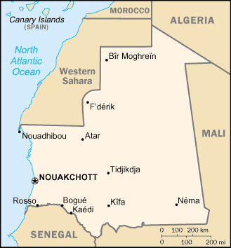
Location:
Location: Northern Africa, bordering the North Atlantic Ocean, between Senegal
and Western Sahara.
Area: total: 1,030,700 sq km, land: 1,030,400 sq km, water: 300 sq km.
Area - comparative: Slightly larger than three times the size of New Mexico.
Land boundaries: Total: 5,074 km, border countries: Algeria 463 km, Mali 2,237
km, Senegal 813 km, Western Sahara 1,561 km.
Coastline: 754 km
Climate and Terrain:
Climate: Desert; constantly hot, dry, dusty
Terrain: Mostly barren, flat plains of the Sahara; some central hills.
Natural resources: Iron ore, gypsum, copper, phosphate, diamonds, gold, oil,
fish.
Geography - note: Most of the population concentrated in the cities of
Nouakchott and Nouadhibou and along the Senegal River in the southern part of
the country.
People:
Population: 2,912,584.
Ethnic groups: Mixed Maur/black 40%, Maur 30%, black 30%.
Religions: Muslim.
Languages: Hassaniya Arabic (official), Pulaar, Soninke, Wolof (official),
French.
Government:
Government type: Republic.
Capital: Nouakchott.
Independence: 28 November 1960 (from France.)
Economy overview:
Half the population still depends on agriculture and livestock for a
livelihood, even though many of the nomads and subsistence farmers were forced
into the cities by recurrent droughts in the 1970s and 1980s. Mauritania has
extensive deposits of iron ore, which account for nearly 40% of total exports.
The decline in world demand for this ore, however, has led to cutbacks in
production. The nation's coastal waters are among the richest fishing areas in
the world, but overexploitation by foreigners threatens this key source of
revenue. The country's first deepwater port opened near Nouakchott in 1986.
Statistics:
Telephones - main lines in use: 26,500.
Telephones - mobile cellular: 35,000.
Radio broadcast stations: AM 1, FM 14, shortwave 1.
Radios: 410,000.
Television broadcast stations: 1.
Televisions: 98,000.
Internet users: 7,500.
Railways: 717 km.
Highways: Total: 7,720 km, paved: 830 km, unpaved: 6,890 km.
Airports - with paved runways: 10,
with unpaved runways: 16.
Return to Visiting Locations
|