|
Mayotte
Background:
Mayotte was ceded to France along with the other islands of the Comoros group
in 1843. It was the only island in the archipelago that voted in 1974 to retain
its link with France and forego independence.
Location:
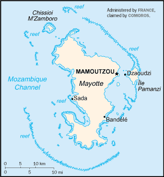
Location: Southern Africa, island in the Mozambique Channel, about one-half of
the way from northern Madagascar to northern Mozambique
Area: total: 374 sq km.
Area - comparative: Slightly more than twice the size of Washington, DC.
Coastline: 185.2 km.
Climate and Terrain:
Climate: Tropical; marine; hot, humid, rainy season during northeastern monsoon
(November to May); dry season is cooler (May to November).
Terrain: Generally undulating, with deep ravines and ancient volcanic peaks.
Geography - note: Part of Comoro Archipelago; 18 islands.
People:
Population: 178,437.
Government:
Dependency status: Territorial collectivity of France.
Capital: Mamoutzou.
Economy overview:
Economic activity is based primarily on the agricultural sector, including
fishing and livestock raising. Mayotte is not self-sufficient and must import a
large portion of its food requirements, mainly from France. The economy and
future development of the island are heavily dependent on French financial
assistance, an important supplement to GDP. Mayotte's remote location is an
obstacle to the development of tourism.
Statistics:
Telephones - main lines in use: 12,000.
Radio broadcast stations: AM 1, FM 5.
Television broadcast stations: 3.
Televisions: 3,500.
Railways: 0 km.
Highways: Total: 93 km, paved: 72 km, unpaved: 21 km.
Airports: 1.
Return to Visiting Locations
|