|
Niger
Background:
Not until 1993, 33 years after independence from France, did Niger hold it's
first free and open elections. A 1995 peace accord ended a five-year Tuareg
insurgency in the north. Coups in 1996 and 1999 were followed by the creation
of a National Reconciliation Council that effected a transition to civilian
rule by December 1999.
Location:
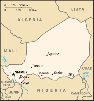
Location: Western Africa, southeast of Algeria.
Area: Total: 1.267 million sq km, water: 300 sq km, land: 1,266,700 sq km.
Area - comparative: Slightly less than twice the size of Texas.
Land boundaries: Total: 5,697 km, border countries: Algeria 956 km, Benin 266
km, Burkina Faso 628 km, Chad 1,175 km, Libya 354 km, Mali 821 km, Nigeria
1,497 km.
Coastline: 0 km (landlocked).
Climate and Terrain:
People:
Population: 11,058,590.
Ethnic groups: Hausa 56%, Djerma 22%, Fula 8.5%, Tuareg 8%, Beri Beri (Kanouri)
4.3%, Arab, Toubou, and Gourmantche 1.2%, about 1,200 French expatriates.
Religions: Muslim 80%, remainder indigenous beliefs and Christian.
Languages: French (official), Hausa, Djerma.
Government:
Government type: Republic.
Capital: Niamey.
Independence: 3 August 1960 (from France).
Economy overview:
Niger is a poor, landlocked Sub-Saharan nation, whose economy centers on
subsistence agriculture, animal husbandry, and re-export trade, and increasingly
less on uranium, because of declining world demand. The 50% devaluation of the
West African franc in January 1994 boosted exports of livestock, cowpeas,
onions, and the products of Niger's small cotton industry. The government
relies on bilateral and multilateral aid - which was suspended following the
April 1999 coup d'etat - for operating expenses and public investment. In
2000-01, the World Bank approved a structural adjustment loan of $105 million
to help support fiscal reforms. However, reforms could prove difficult given
the government's bleak financial situation. The IMF approved a $73 million
poverty reduction and growth facility for Niger in 2000 and announced $115
million in debt relief under the Heavily Indebted Poor Countries (HIPC)
initiative. Further disbursements of aid occurred in 2002. Future growth may be
sustained by exploitation of oil, gold, coal, and other mineral resources.
Statistics:
Telephones - main lines in use: 20,000.
Telephones - mobile cellular: 6,700.
Radio broadcast stations: AM 5, FM 6, shortwave 4.
Radios: 680,000.
Television broadcast stations: 3 (plus seven low-power repeaters).
Televisions: 125,000.
Internet users: 12,000.
Railways: 0 km.
Highways: Total: 10,100 km, paved: 798 km, unpaved: 9,302 km.
Airports - with paved runways: 9, with unpaved runways: 18.
Return to Visiting Locations
|