|
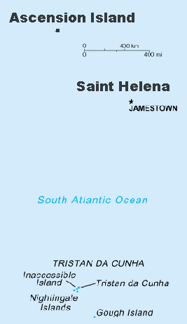
Saint Helena (includes Ascension Island)
Background:
Uninhabited when first discovered by the Portuguese in 1502, the British
garrisoned Saint Helena during the 17th century. It acquired fame as the place
of Napoleon Bonaparte's exile, from 1815 until his death in 1821, but its
importance as a port of call declined after the opening of the Suez Canal in
1869. Ascension Island is the site of a US Air Force auxiliary airfield; Gough
Island has a meteorological station.
Location:
Islands in the South Atlantic Ocean, about midway between South America and
Africa
Area: Total: 410 sq km note: includes St. Helena Island, Ascension, and the
island group of Tristan da Cunha, which consists of Tristan da Cunha Island,
Gough Island, Inaccessible Island, and the three Nightingale Islands. Water: 0
sq km, land: 410 sq km.
Area - comparative: Slightly more than twice the size of Washington, DC
Coastline: 60 km
Climate and Terrain:
Climate: Saint Helena - tropical; marine; mild, tempered by trade winds;
Tristan da Cunha - temperate; marine, mild, tempered by trade winds (tends to
be cooler than Saint Helena).
Terrain: Saint Helena - rugged, volcanic; small scattered plateaus and plains,
note: the other islands of the group have a volcanic origin.
Elevation extremes: Lowest point: Atlantic Ocean 0 m, highest point: Queen
Mary's Peak on Tristan da Cunha 2,060 m.
People:
Population: 7,317.
Ethnic groups: African descent 50%, white 25%, Chinese 25%.
Religions: Anglican (majority), Baptist, Seventh-Day Adventist, Roman Catholic.
Languages: English.
Government:
Dependency status: Overseas territory of the UK.
Capital: Jamestown.
Economy overview:
The economy depends largely on financial assistance from the UK, which amounted
to about $5 million in 1997 or almost one-half of annual budgetary revenues.
The local population earns income from fishing, the raising of livestock, and
sales of handicrafts. Because there are few jobs, 25% of the work force has
left to seek employment on Ascension Island, on the Falklands, and in the UK.
Labor force - by occupation: Agriculture and fishing 6%, industry (mainly
construction) 48%, services 46%.
Industries: Construction, crafts (furniture, lacework, fancy woodwork),
fishing.
GDP - composition by sector: Agriculture: 17%, industry: 30%, services: 53%.
Statistics:
Telephones - main lines in use: 2,000.
Telephones - mobile cellular: 0 (1997.)
Radio broadcast stations: AM 1, FM 0, shortwave 0 .
Radios: 3,000.
Television broadcast stations: 0 (1997).
Televisions: 2,000 (1997).
Railways: 0 km.
Highways: Total: 158 km (Saint Helena 118 km, Ascension 40 km, Tristan da Cunha
0 km), paved: 138 km (Saint Helena 98km, Ascension 40 km, Tristan da Cunha 0
km), unpaved: 20 km (Saint Helena 20 km, Ascension 0 km, Tristan da Cunha 0
km).
Ports and harbors: Georgetown (on Ascension), Jamestown
Airports - with paved runways: Total: 1.
Return to Visiting Locations
|