|
Saint Lucia
Background:
The island, with its fine natural harbor at Castries, was contested
between England and France throughout the 17th and early 18th centuries
(changing possession 14 times); it was finally ceded to the UK in 1814.
Self-government was granted in 1967 and independence in 1979.
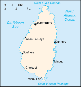
Location:
Caribbean, island between the Caribbean Sea and North Atlantic Ocean,
north of Trinidad and Tobago.
Area: Total: 620 sq km.
Area - comparative: 3.5 times the size of Washington, DC.
Coastline: 158 km.
Climate and Terrain:
Climate: Tropical, moderated by northeast trade winds; dry season from January
to April, rainy season from May to August.
Terrain: Volcanic and mountainous with some broad, fertile valleys.
Elevation extremes: Lowest point: Caribbean Sea 0 m highest point: Mount
Gimie 950 m.
Natural resources: Forests, sandy beaches, minerals (pumice), mineral springs,
geothermal potential.
Land use: Arable land: 8% permanent crops: 21%, permanent pastures: 5%
forests and woodland: 13%, other: 53%.
People:
Population: 158,178 (July 2001 est.)
Ethnic groups: Black 90%, mixed 6%, East Indian 3%, white 1%.
Religions: Roman Catholic 90%, Protestant 7%, Anglican 3%.
Languages: English (official), French patois.
Government:
Government type: Westminster-style parliamentary democracy
Capital: Castries
Economy overview:
The recent changes in the EU import preference regime and
the increased competition from Latin American bananas have made economic
diversification increasingly important in Saint Lucia. Improvement in the
construction sector and growth of the tourism industry helped expand GDP in
1998-99. The agriculture sector registered its fifth year of decline in 1997
primarily because of a severe decline in banana production. The manufacturing
sector is the most diverse in the Eastern Caribbean, and the government is
beginning to develop regulations for the small offshore financial sector.
GDP - composition by sector: Agriculture: 10.7% industry: 32.3%
services: 57%.
Labor force: 43,800.
Labor force - by occupation: Agriculture 43.4%, services 38.9%, industry and
commerce 17.7%.
Industries: Clothing, assembly of electronic components, beverages, corrugated
cardboard boxes, tourism, lime processing, coconut processing.
Statistics:
Telephones - main lines in use: 37,000.
Telephones - mobile cellular: 1,600.
Radio broadcast stations: AM 2, FM 7.
Radios: 111,000.
Television broadcast stations: 3.
Televisions: 32,000.
Internet country code: .lc
Internet Service Providers (ISPs): 15.
Internet users: 5,000.
Highways: total: 1,210 km paved: 63 km unpaved: 1,147 km.
Airports - with paved runways: 2.
Return to Visiting Locations
|