|
Saint Vincent and the Grenadines
Background:
Disputed between France and the United Kingdom in the 18th century, Saint
Vincent was ceded to the latter in 1783. Autonomy was granted in 1969 and
independence in 1979.
Location:
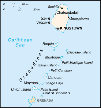
Location: Caribbean, islands between the Caribbean Sea and North Atlantic
Ocean, north of Trinidad and Tobago.
Area: Total: 389 sq km (Saint Vincent 344 sq km).
Area - comparative: Twice the size of Washington, DC.
Coastline: 84 km.
Climate and Terrain:
Climate: Tropical; little seasonal temperature variation; rainy season (May to
November).
Terrain: Volcanic, mountainous.
People:
Population: 116,812.
Ethnic groups: Black 66%, mixed 19%, East Indian 6%, Carib Amerindian 2%, other
7%.
Religions: Anglican 47%, Methodist 28%, Roman Catholic 13%, Hindu Seventh-Day
Adventist, other Protestant.
Languages: English, French patois.
Government:
Government type: Parliamentary democracy; independent sovereign state within
the Commonwealth.
Capital: Kingstown.
Independence: 27 October 1979 (from UK.)
Geography - note: The
administration of the islands of the Grenadines group is
divided between Saint Vincent and the Grenadines and Grenada; Saint Vincent and
the Grenadines is comprised of 32 islands and cays.
Economy overview:
Bananas and other agricultural products remain the staple of this lower-middle
income country's economy. Although tourism and other services have been growing
moderately in recent years, the government has been ineffective at introducing
new industries. Unemployment remains high, and economic growth hinges upon
seasonal variations in the agricultural and tourism sectors. Tropical storms
wiped out substantial portions of crops in 1994, 1995, and 2002, and tourism in
the Eastern Caribbean has suffered low arrivals following 11 September 2001.
Saint Vincent is home to a small offshore banking sector, but its restrictive
secrecy laws have come under international review. As of June 2001, it remained
on the Financial Action Task Force's list of noncooperative jurisdictions.
Saint Vincent is also the largest producer of marijuana in the Eastern
Caribbean and is increasingly being used as a transshipment point for illegal
narcotics from South America.
Statistics:
Telephones - main lines in use: 20,500 .
Radio broadcast stations: AM 1, FM 3.
Radios: 77,000.
Television broadcast stations: 1 (plus three repeaters).
Televisions: 18,000.
Internet users: 3,500.
Railways: 0 km
Highways: Total: 1,040 km, paved: 320 km, unpaved: 720 km.
Airports - with paved runways: 5, with unpaved runways: 1.
Return to Visiting Locations
|