|
Suriname
Background:
Independence from the Netherlands was granted in 1975. Five years later the
civilian government was replaced by a military regime that soon declared a
socialist republic. It continued to rule through a succession of nominally
civilian administrations until 1987, when international pressure finally forced
a democratic election. In 1989, the military overthrew the civilian government,
but a democratically-elected government returned to power in 1991.
Location:
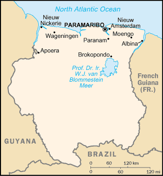
Location: Northern South America, bordering the North Atlantic Ocean, between
French Guiana and Guyana.
Area: Total: 163,270 sq km, land: 161,470 sq km, water: 1,800 sq km.
Area - comparative: Slightly larger than Georgia.
Land boundaries: Total: 1,707 km, border countries: Brazil 597 km, French
Guiana 510 km, Guyana 600 km.
Coastline: 386 km.
Climate and Terrain:
People:
Population: 435,449.
Ethnic groups: Hindustani (also known locally as "East Indians"; their
ancestors emigrated from northern India in the latter part of the 19th century)
37%, Creole (mixed white and black) 31%, Javanese 15%, "Maroons" (their African
ancestors were brought to the country in the 17th and 18th centuries as slaves
and escaped to the interior) 10%, Amerindian 2%, Chinese 2%, white 1%, other
2%.
Religions: Hindu 27.4%, Muslim 19.6%, Roman Catholic 22.8%, Protestant 25.2%
(predominantly Moravian), indigenous beliefs 5%.
Languages: Dutch (official), English (widely spoken), Sranang Tongo
(Surinamese, sometimes called Taki-Taki, is native language of Creoles and much
of the younger population and is lingua franca among others), Hindustani (a
dialect of Hindi), Javanese.
Government:
Government type: Constitutional democracy.
Capital: Paramaribo.
Independence: 25 November 1975 (from Netherlands).
Economy overview:
The economy is dominated by the bauxite industry, which accounts for more than
15% of GDP and 70% of export earnings. Suriname's economic prospects for the
medium term will depend on renewed commitment to responsible monetary and
fiscal policies and to the introduction of structural reforms to liberalize
markets and promote competition. The government of Ronald Venetiaan has begun
an austerity program, raised taxes, and attempted to control spending. The
Dutch Government has agreed to restart the aid flow, which will allow Suriname
to access international development financing.
Statistics:
Telephones - main lines in use: 64,000.
Telephones - mobile cellular: 4,090.
Radio broadcast stations: AM 4, FM 13, shortwave 1.
Radios: 300,000.
Television broadcast stations: 3 (plus seven repeaters).
Televisions: 63,000.
Internet users: 14,500.
Railways: Total: 166 km.
Highways: Total: 4,492 km, paved: 1,168 km, unpaved: 3,324 km.
Airports - with paved runways: 5 with unpaved runways: 41.
Return to Visiting Locations
|