|
Uruguay
Background:
A violent Marxist urban guerrilla movement, the Tupamaros, launched in the late
1960s, led Uruguay's president to agree to military control of his
administration in 1973. By the end of the year the rebels had been crushed, but
the military continued to expand its hold throughout the government. Civilian
rule was not restored until 1985. Uruguay's political and labor conditions are
among the freest on the continent.
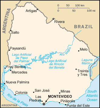
Location:
Southern South America, bordering the South Atlantic Ocean, between Argentina
and Brazil
Area: Total: 176,220 sq km, land: 173,620 sq km, water: 2,600 sq km.
Area - comparative: Slightly smaller than the state of Washington.
Land boundaries: Total: 1,564 km, border countries: Argentina 579 km, Brazil
985 km.
Coastline: 660 km.
Climate and Terrain:
Climate: Warm temperate; freezing temperatures almost unknown.
Terrain: Mostly rolling plains and low hills; fertile coastal lowland
Natural resources: Arable land, hydropower, minor minerals, fisheries.
People:
Population: 3,386,575.
Ethnic groups: White 88%, Mestizo 8%, black 4%, Amerindian, practically
nonexistent.
Religions: Roman Catholic 66% (less than half of the adult population attends
church regularly), Protestant 2%, Jewish 1%, nonprofessing or other 31%.
Languages: Spanish, Portunol, or Brazilero (Portuguese-Spanish mix on the
Brazilian frontier).
Government:
Government type: Constitutional republic.
Capital: Montevideo.
Independence: 25 August 1825 (from Brazil).
Economy overview:
An export-oriented agricultural sector, a well-educated workforce, and high
levels of social spending characterize Uruguay's economy. After averaging
growth of 5% annually in 1996-98, in 1999-2001 the economy suffered from lower
demand in Argentina and Brazil, which together account for nearly half of
Uruguay's exports. Despite the severity of the trade shocks, Uruguay's
financial indicators remained more stable than those of its neighbors, a
reflection of its solid reputation among investors and its investment-grade
sovereign bond rating - one of only two in South America. Challenges for the
government of President Jorge Batlle include reducing the budget deficit,
expanding Uruguay's trade ties beyond its Mercosur trade partners, and reducing
the costs of public services. GDP fell by 1.3% in 2000 and by 1.5% in 2001.
GDP - composition by sector: Agriculture: 6%, industry: 29%, services: 65%.
Statistics:
Telephones - main lines in use: 929,141.
Telephones - mobile cellular: 350,000.
Radio broadcast stations: AM 91, FM 149, shortwave 7.
Radios: 1.97 million.
Television broadcast stations: 20.
Televisions: 782,000.
Internet users: 370,000.
Railways: Total: 2,993 km.
Highways: Total: 8,764 km, paved: 7,800 km, unpaved: 964 km.
Airports: 64, with paved runways: 15, with unpaved runways: 49.
Return to Visiting Locations
|