|
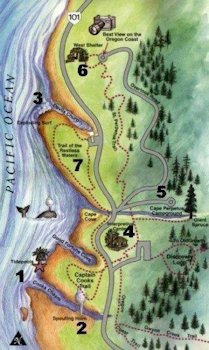
Cape Perpetua Scenic Area, Oregon Coast - - 1. Map of the Cape Perpetua Area Looming over tiny Yachats is the impressive bulk of 800-foot-high Cape Perpetua, the highest spot on the Oregon coast. Because of the cape's rugged beauty and diversity of natural habitats, it has been designated the Cape Perpetua Scenic Area. The Cape Perpetua Interpretive Center (tel. 541/547-3289) is on a steep road off U.S. 101 and houses displays on the natural history of the cape and the Native Americans who harvested its bountiful seafood for thousands of years. The visitor center is open daily from 9am to 5pm between Memorial Day and Labor Day. Admission is $5 per vehicle, but free to Golden Age Passport holders. Within the scenic area are 18 miles of hiking trails, tide pools, ancient forests, scenic overlooks, and a campground. During the summer, guided hikes are offered. If you're here on a clear day, be sure to drive to the top of the cape for one of the finest vistas on the coast. Waves and tides are a year-round source of fascination along these rocky shores, and Cape Perpetua's tide pools are some of the best on the coast. There's good access to the tide pools at the pull-off at the north end of the scenic area. However, it is the more dramatic interactions of waves and rocks that attract most people to walk the oceanside trail here: Below at the Devil's Churn waves boil through a narrow opening in the rocks. Nearby lies Cooks Chasm and a Spouting Horn, caused by waves crashing into a narrow fissure in the basalt shoreline sends geyser-like plumes of water skyward lies below.
|