|
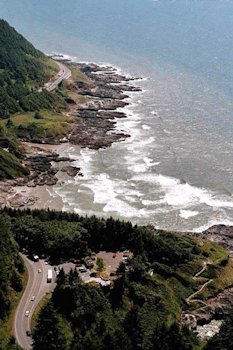
Devil's Churn State Park, Oregon Coast 2. View of the Cape Perpetua Area A view from the 800-foot-high Cape Perpetua, the highest spot on the Oregon coast. If you're here on a clear day, be sure to drive to the top of the cape for one of the finest vistas on the coast. Waves and tides are a year-round source of fascination along these rocky shores, and Cape Perpetua's tide pools are some of the best on the coast. There's good access to the tide pools at the pull-off at the north end of the scenic area. Seen at the lower right you can see the parking area for the Devil's Churn where waves boil through a narrow opening in the rocks. The trail to the bottom can be seen and just a small piece of the Churn itself. Farther up lies Cook's Chasm and Spouting Horn, caused by waves crashing into a narrow fissure in the basalt shoreline sends geyser-like plumes of water skyward. ⇦ Back to Page 1 On to Page 3Return to Devil's Churn Page 1 |